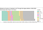
TidyTuesdayArtHistoryData
Using the TidyTuesday Art History Data, I’ve created two plots. One is a ggstream plot organized by artist_race in the dataset. {width = 100%}
The seocnd is using ggwaffle organized by country.
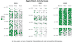
Analysis of Apple Health Data using TidyVerse
I have always been very interested in keeping track of my workout activities, especially since I got an Apple Watch. This has really propelled me to become very obsessed with tracking nearly all my walks and hikes.
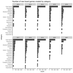
Board Games TidyTuesday
This is my contribution to 2022, Week 4 TidyTuesday using data from Board Game Geek.
Starting with the packages and cleaning up the data. Some games are associated with multiple categories of board games.
Chocolate Ratings-Tidy Tuesday Week 3
This week for #TidyTuesday the dataset comes from Flavors of Cacao. Interesting set of information on chocolate ratings from across the world. Code below the figures. I first wanted to look at the data statistically.

Bee Colony Changes - Tidy Tuesday 2022
This week for ‘#TidyTuesday’ used bee colony data collected by USDA at the state level for the US. Check it out here I decided to look at the average percent of colony decline in each state, for the last four years.

Starbucks Tidy Tuesday 2021 Week 52
This is my contribution for #TidyTuesday, after a long time of not participating. I created an interactive plot using ggplot and plotly packages that compares the calories vs caffeine content of Starbucks drinks.
Landscape Metrics and Percent Land Use of Polygons
still work in progress I previously used the program FRAGSTATS a few times while in graduate school but never quite got the hang of it. Instead of struggling with FRAGSTATS, a friend and colleague Nick Yarmey used the LandscapeMetrics package to do the same calculations.
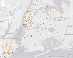
NYC Urban Ranger Animal Response
I came across this dataset from NYC from Urban Park Ranger Animal Condition Response datasource. From May 2018 - June 2019, data was collected on animal calls received by the Urban Park Rangers of New York City.
Geocoding Points by Place Name using ArcGIS Online
This is the second post to using the Urban Ranger Response Call from NYC Open Data first post. The data did not have specific location information, such as XY coordinates, but there was a field Property in the database.
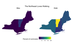
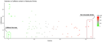
Walkability
tidy tuesday walkability