Steven DiFalco

Steven DiFalco

GIS and Land Data Manger

Scenic Hudson

Biography

As the GIS and Land Data Manager at Scenic Hudson, I administer GIS and Salesforce-based land records. I assist our 35 users on using ArcGIS products for all cartographic and field data colleciton needs. I completed my master’s degree in Natural Resources at the University of Connecticut, where I studied the human dimensions of exurban utility vegetation management. My research project involved a mail survey to residents of Connecticut, to assess public perceptions and opinions towards tree management. I integrated spatial analysis techniques to evaluate how attitudes vary across the landscape at different scales.
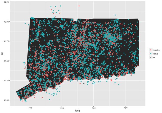
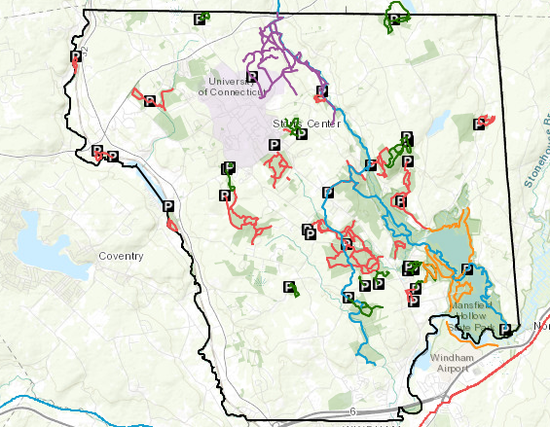
For five years, I worked as a natural resource specialist to restore native ecosystems through invasive plant management. I focused on restoring forests and fields to their native composition, by collecting and propagating native plants to establish a diverse assemblage of species. I am interested in the way exotic invasive species affect local ecosystems, and best management practices to mitigate the impacts of invasive species. Restoring and maintaining native plant populations is important for helping provide habitat for our native pollinators, which are an overlooked aspect of our ecosystem.

Interview with Naturally@UConn

Interests

  • Cartography
  • Land conservation
  • Spatial analysis
  • Human-environmental interactions
  • Invasive species
  • Habitat restoration

Education

  • MS in Natural Resources, 2020

    University of Connecticut

  • BS in Environmental Biology, 2013

    State University of New York at New Paltz

Recent Posts

TidyTuesdayArtHistoryData

Using the TidyTuesday Art History Data, I’ve created two plots. One is a ggstream plot organized by artist_race in the dataset. {width = 100%} The seocnd is using ggwaffle organized by country.

Analysis of Apple Health Data using TidyVerse

I have always been very interested in keeping track of my workout activities, especially since I got an Apple Watch. This has really propelled me to become very obsessed with tracking nearly all my walks and hikes.

Board Games TidyTuesday

This is my contribution to 2022, Week 4 TidyTuesday using data from Board Game Geek. Starting with the packages and cleaning up the data. Some games are associated with multiple categories of board games.

Chocolate Ratings-Tidy Tuesday Week 3

This week for #TidyTuesday the dataset comes from Flavors of Cacao. Interesting set of information on chocolate ratings from across the world. Code below the figures. I first wanted to look at the data statistically.

Bee Colony Changes - Tidy Tuesday 2022

This week for ‘#TidyTuesday’ used bee colony data collected by USDA at the state level for the US. Check it out here I decided to look at the average percent of colony decline in each state, for the last four years.

Starbucks Tidy Tuesday 2021 Week 52

This is my contribution for #TidyTuesday, after a long time of not participating. I created an interactive plot using ggplot and plotly packages that compares the calories vs caffeine content of Starbucks drinks.

Landscape Metrics and Percent Land Use of Polygons

still work in progress I previously used the program FRAGSTATS a few times while in graduate school but never quite got the hang of it. Instead of struggling with FRAGSTATS, a friend and colleague Nick Yarmey used the LandscapeMetrics package to do the same calculations.

NYC Urban Ranger Animal Response

I came across this dataset from NYC from Urban Park Ranger Animal Condition Response datasource. From May 2018 - June 2019, data was collected on animal calls received by the Urban Park Rangers of New York City.

Geocoding Points by Place Name using ArcGIS Online

This is the second post to using the Urban Ranger Response Call from NYC Open Data first post. The data did not have specific location information, such as XY coordinates, but there was a field Property in the database.

Walkability

tidy tuesday walkability

Volcanos Data TidyTuesday

This is my contribution to TidyTuesday In this, I’m attempting to use the gganimate package for the first time to create an animation showing volcanoe eruptions over the past century and their location.

Projects

*

Other Projects

Examples of other projects using Python for a mapping project and iNaturalist data.

Mansfield Trail Mapper

Trail map for the town of Mansfield, CT made with ArcOnline.

Selected Experiences


GIS and Land Data Manager

Scenic Hudson

Mar 2022 – Present Poughkeepsie, NY

Responsibilities include:

  • Mapping and completing analysis for various land protection projects including impacts of development proposals on scenic,agricultural, urban and ecological resources
  • Maintaining all spatial and tabular data related to landconservation, land use, natural and cultural resources, trails and other recreational features
  • Organizing trainings, mentoring and technical assistance to GIS and Salesforce users within the organization


Land Projects Coordinator

Westchester Land Trust

Aug 2020 – Mar 2022 Bedford, NY

Responsibilities include:

  • Assisted with the identification and management of land conservation projects
  • Updated organization strategic conservation plan including data collection and spatial analysis modeling for priority conservation projects
  • Supported the stewardship department with conservation easement monitoring and preserve management activities


Graduate Research Assistant

University of Connecticut

Jan 2018 – Dec 2020 Storrs, CT

Responsibilities include:

  • Planned and conducted research pertaining to socioecological research on attitudes of residents towards roadside vegetation management practices
  • Integrated human dimensions, landscape ecology, and spatial analysis to analyze data
  • Supervised 10 research technicians in survey data entry, point geolocation, mapping, and data analysis


Natural Resource Supervisor

Rockefeller State Park Preserve

Apr 2016 – Jan 2018 Pleasantville, NY

Responsibilities included:

  • Coordinated and implemented restoration of natural areas through invasive species management, reestablishing native plant populations, and mitigating soil erosion
  • Conducted vegetation monitoring and deer browse impact research, oversaw bow hunt, and coordinated with external researchers for blue bird banding, wood thrush monitoring, and deer spotlight surveys; generated annual reports for funding agency
  • Recruited and supervised natural resource stewards, interns, and volunteers
  • Managed restoration budget for plant materials and invasive herbicide contracts
  • Partnered with local and state organizations to advance ecological restoration


Forest Ecologist

Prospect Park Alliance

Jul 2014 – Mar 2016 Brooklyn, NY

Responsibilities included:

  • Prioritized management and restoration of invasive plant infestations using herbicides
  • Conducted long-term vegetation monitoring and data analysis for reports
  • Coordinated, hired, and supervised the natural resource internship program
  • Organized and oversaw frequent volunteer projects and plant identification tours

Accomplish­ments

Cartography Course

Learn to make beautiful maps using ArcGIS Pro

Contact